
Coasts 2024, 4(1), 21-33; https://doi.org/10.3390/coasts4010002 - 04 Jan 2024
Abstract
►
Show Figures
“Red tide” is the popular name for a harmful algal bloom that occurs frequently in Florida waters and has significant impacts on the environment, the economy, and human and animal health. This paper addresses the limited understanding of public attitudes surrounding red tide
[...] Read more.
“Red tide” is the popular name for a harmful algal bloom that occurs frequently in Florida waters and has significant impacts on the environment, the economy, and human and animal health. This paper addresses the limited understanding of public attitudes surrounding red tide and the potential for message framing to increase support for mitigation action. A sample of Florida residents (n = 498) was randomly shown a digital article framed around different red tide impacts (economic loss, human health risks, ecosystem damage, or harm to charismatic species) or a control article not framed around a specific red tide impact. Participants were then queried about their emotional responses, support for red tide mitigation policies, and intentions to change their behavior to mitigate impacts. Participants reported higher levels of negative emotions after viewing the harm to charismatic megafauna framing, indicating that messaging may play a significant role in eliciting environmental emotions. Message frames did not significantly impact other policy attitudes. Results demonstrate barriers to shifting support for mitigation where public support for action is already high.
Full article
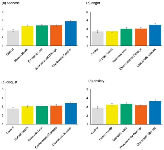
Figure 1


