


Land 2024, 13(1), 98; https://doi.org/10.3390/land13010098 - 15 Jan 2024
Abstract
Over the past two decades, the rate of urbanization has increased significantly worldwide, with more than half of the population already living in cities; this trend continues in numerous countries and regions. Tunisia is a North African country with a rich history and
[...] Read more.
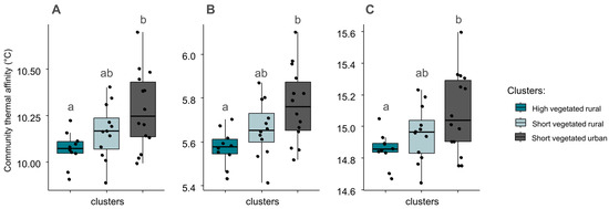
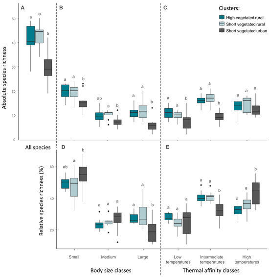
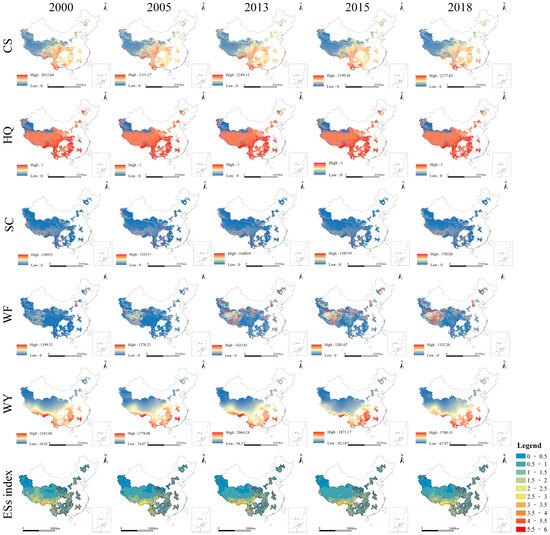
Over the past two decades, the rate of urbanization has increased significantly worldwide, with more than half of the population already living in cities; this trend continues in numerous countries and regions. Tunisia is a North African country with a rich history and diverse cultural heritage. In Greater Tunis, its capital city, urbanization has accelerated since 1960. Rapid urbanization has increased the demand for grey infrastructure and led to changes in land-use patterns and the destruction of the environment. This study aims to understand and depict the relationship between urban expansion and the green infrastructure in the Greater Tunis area. This study uses land-use data, administrative boundaries vector data, and Google satellite imagery datasets to calculate and analyze the changes in the land use transfer matrix and landscape pattern index of built-up land and green spaces in the Tunisian capital for three periods: 2000, 2010, and 2020. We found that the expansion of built-up areas in Tunis has increased from 8.8% in 2000 to 12.1% in 2020, and changes in green spaces have decreased from 23% in 2000 to 20.9% in 2020. Without planning guidelines, the layout of green spaces has become more fragmented and disorganized. For this reason, we provide programs and suggestions for building a complete ecological network of green spaces in order to provide references and lessons for related studies and cities facing the same problems.
Full article
(This article belongs to the Special Issue Sustainable Land-Use Dynamics and Green Infrastructure Mapping)


